

Digital Orthophoto Maps - OrthoHELLAS
Digital Orthophoto maps constitute a contemporary mapping product, which combines the metric quality and accuracy of a topographic diagram and the volume and quality of information provided by a high-resolution digital aerial photograph.
The production of digital orthophoto maps has been made possible in the last few years as a result of the rapid development of computers and the increase of computing power, as well as the development of the appropriate software products.
Thanks to its vertical structure, which allows the company to fully cover the complete spectrum of digital orthophoto map production procedures (aerial photography acquisition, field work, photogrammetric processing), Geomatics is currently the leading company in this technological field, as well as the biggest producer and provider of digital orthophoto maps in Greece.
We are capable to readily produce high quality color orthophoto maps of every part of the country, utilising either the existing aerial photographs or new ones, by realizing aerial photography acquisitions according to the clients' needs and demands.
The company's orthophoto maps archive covers, among others, the following areas:
- Attica Prefecture - Color and B/W orthophoto maps at a scale corresponding to 1:5.000 and spatial resolution (GSD) of 0.50 m & 1.0 m.
- Thessaloniki Residential Complex - Color and B/W orthophoto maps at a scale corresponding to 1:5.000 and spatial resolution (GSD) of 0.50 m and 1,00 m.
- Prefecture Capitals - Scale corresponding to 1:5.000 and spatial resolution (GSD) of 0.50 m
- Parts of the Country - Scale corresponding to 1:5.000 and spatial resolution (GSD) of 1.0 m - 1:10.000 scale and 2.0 m GSD - 1:20.000 scale and 5.0 m GSD
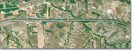
- Roads and Highways - 1:2.000 scale and 0.50 m, 0.25 m GSD, 1:5.000 scale and 0.50 m GSD
- Railway lines - Scales of 1:5.000, 1:2.000 and 0.50 m, 0.25 m GSD